Rome Metro Line A 2025
Updated: January 2025
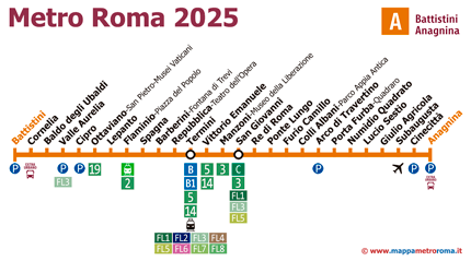
Welcome. Here you will find the most complete and updated map of the Rome Metro Line A. As frequent users of the Rome metro, we decided to create the maps we would have liked to have available.
In this updated map, we have included all the metro stops up to January 2025. Unlike other maps available online, ours is constantly updated.
You can download any of our maps to your hard drive, print them or do whatever you like, but please, do not copy them onto other websites, nor create direct links to the images, because we update them with new information constantly.
→ Click to enlarge ←

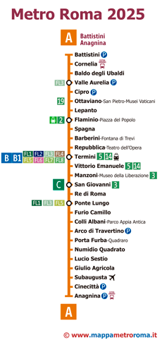
→ Click to enlarge ←

Our map of Line A does not follow the traditional design of station maps. We have opted for a more modern style, inspired by subway maps of other major cities, to make it more functional and easy to use.
Map | Timetable | Prices | Line A | Line B | Line C
Curiosities about the Rome Metro Line A
- Inauguration and evolution: The Rome Metro Line A, inaugurated on February 19, 1980, was not the first subway line to be operational in the city. Its construction began in 1964 and was hindered by archaeological discoveries, particularly in the area of Piazza della Repubblica. These discoveries led to a change in construction techniques, from open-air excavations to underground methods.
- Extension and stations: This line, known for its orange color, runs from the northeast to the southeast of Rome, with 27 stations. Among the most important stations are Ottaviano, near the Vatican, and Barberini, close to the Trevi Fountain.
- Operation and passenger transport: It makes 290 trips a day in each direction, with a train frequency of every two minutes during peak hours. It transports about 450,000 passengers per day.
- Key connections: Line A allows exchanges with lines B and C of the subway, several suburban lines, and the Leonardo Express train connecting to Rome-Fiumicino Airport.
- Future expansions: There are plans to extend Line A northwards with two new underground stations and southeastwards with a light metropolitan train connecting Anagnina station of Line A with Torre Angela station of Line C.
Stations of the Rome Metro Line A
Here you can find the list of all the stations of the Metro Line A:| Battistini | |
| Cornelia | |
| Baldo degli Ubaldi | |
| Valle Aurelia | |
| Cipro | |
| Ottaviano-San Pietro-Musei Vaticani | |
| Lepanto | |
| Flaminio-Piazza del Popolo | |
| Spagna | |
| Barberini-Fontana di Trevi | |
| Repubblica-Teatro dell’Opera | |
| Termini | |
| Vittorio Emanuele | |
| Manzoni-Museo della Liberazione | |
| San Giovanni | |
| Re di Roma | |
| Ponte Lungo | |
| Furio Camillo | |
| Colli Albani-Parco Appia Antica | |
| Arco di Travertino | |
| Porta Furba-Quadraro | |
| Numidio Quadrato | |
| Lucio Sestio | |
| Giulio Agricola | |
| Subaugusta | |
| Cinecittà | |
| Anagnina |
If you find something wrong on this website, let us know and we will fix it. Thank you very much for stopping by.
